Heading: Long shore Drift
Introduction:
How does long shore drift move material along the coastline?
- Long-shore drift is helped but long shore currents, from waves approaching the beach at an angle and wind pushing water on shore.When the waves move on shore, they stir up sediment.
Visuals and Vocabulary:
long shore current- a current parallel to shore caused by waves approaching the beach at an angle.
long shore drift- the movement of sediment and materials along the coast, caused by a long shore current.

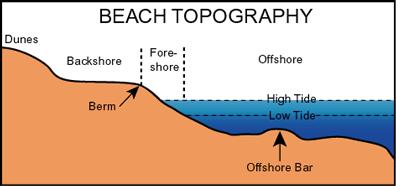
Title: Coastal Dynamics
Heading: Beach Dynamics
Introduction:
Where does sand come from?
- Most sand comes from erosion, which results from streams and rivers that carry it onto the ocean. Sand may come from local rocks, and can also come from portions of coral reef.
- Its composed of the foreshore, back shore, and offshore.
- Interacting factors include the grain size of beach sediments, wave energy, and the degree of beach slope.
- A coastal cell is a local region of material transport mechanisms that, when combined, form an area with no net sand gain or loss.
Visuals and Vocabulary:
bioerosion- erosion caused by species eating coral polyps and excreting sand as digestive waste, the parrotfish is one species that performs this process.
forshore- the region of a beach from the high tide mark to the low tide mark.
backshore- the region of a beach rarely touched by seawater, including dunes or grasses all the way to "non-beach" ground.
lowtide terrance- the flat portion of the foreshore of a beach where the waves break.
offshore- the beach area beyond low-tide terrace; it includes a long shore trough and shallow sandbar that both parallel the shore.
longshore trough- a slightly deeper area in the offshore section of a beach, running parallel to shore.
coastal cell.
Title: Coastal Dynamics
Heading: Large-Scale Sand Features
Introduction:
What causes a spit to form?
- A spit forms when a long shore current turns a beach corner into the relatively calm water of a bay. The current slows and cannot carry as much sediment. Sand settles out of the water, forming the spit.
- Tombolos are spits that extend between two islands or from an island to the mainland. When there is a slower water flow, sand doesn't move that much. The sand eventually accumulates and forms two spits that eventually grow together into a tombolo.
- Barrier islands are rarely the same each day, they gradually move inland as the sea erodes the coast. High winds and storm surges can alter barrier islands within a short period. That's why most people living on barrier islands risk vulnerable situations during hurricanes.
- An ocean beach, sand dunes, a barrier flat, a salt marsh, and a lagoon.
- River dominated deltas have strong rivers, mild waves, and tidal action. They also tend to have a triangle shape, an example is the Mississippi River delta. Tide-dominated deltas occur in areas with strong tidal changes. They usual form tidal channels from ridge sediments. and an example is the Essex River in Massachusetts. Wave-dominated deltas have significant wave energy that redistributes river sediments. An example is the Senegal delta in west Africa.
Visuals and Vocabulary:
spit- a length of accumulated sand attached to land at one end, pointing in the direction of the long shore drift.
bay mouth barrier- a sand barrier created by a spit accumulating so much sediment near the edge of a larger water body.
tombolo- a spit that extends between two islands or between an island and the mainland.
barrier flat- a broad, relatively level area behind the dunes of a barrier island, with vegetation ranging from grasses to woodlands.
salt marsh- an intertidal grassland that is usually biologically diverse and productive.
lagoon- an area of shallow water separated from the ocean by a barrier island or other obstruction.
river-dominated deltas- a delta with a strong river and mild wave and tidal action.
tide-dominated deltas- a delta in an area with strong tides that redistributes accumulating sediments.
wave-dominated deltas- a delta in an area with high wave energy that redistributes accumulating sediments as dunes and spits.

End of Reading:
True/False
1. There are two basic types of dominated deltas
2. A beach is composed of three sections: offshore, foreshore, and backshore.
Multiple Choice
3. Factors that affect the shape and appearance of a beach are:
a) grain size of beach sediments, wave energy, and the degree of beach slope.
b) wave energy, and long shore current
4. Barrier islands are temporary coastal features because:
a) they hardly move at a rapid rate
b) they are very good especially during hurricanes
c) high winds and storm surges can altar them in a short period
Fill-in
5. A _________ delta has the characteristic of a triangle shape.
6. The _________ is that part between the high-tide mark and the low-tide mark.
Summary:
There are many dynamic changes in the world but, the constant change takes place on our coasts. The beach is a common area that moves constantly. Dynamic marine factors that affect this movement are: the wind, the change in sea levels, waves, erosion and many other factors. This section show how sediment and other materials are transported along the coast by longshore currents and longshore drift. It goes into detail about what a beach is composed of and how its appearance can change through energy created by high wave action and backwash. This section also shows significant coastal features and how these features affect the water flow and shape our environment.
Current Research
The impact of climatic change on coastal landsystems: What lies in the future?
The impact of climatic change on coastal landsystems: What lies in the future?
Global warming and its associated climate changes will cause worldwide sea level to rise in this century and beyond, and although dramatic sea-level change has been common throughout the Quaternary, and even in the Holocene, it will impact in a major way on coastal landsystems and the populations that inhabit the coast. The aim of this section is to provide a summary of the likely effects of sea-level rise on the various types of coast and then undertake a detailed case study to examine the effects in more detail.
Currently there are several calculations of the extent of future sea-level rise, but most predict a rise of 10–15 cm by 2030, accelerating to 30–80 cm by 2100. Such rises will cause major coastal changes around the world. Eventually all of the world’s coastlines will be submerging coastlines, even in areas that are stil emerging after the effects of the last glacial, like the Gulf of Bothnia. There will be extensive submergence of low-lying coastal areas and current intertidal areas will be no more. On rocky coastlines sea-level rise will just raise the high- and low-tide levels, although the amount of marine erosion is likely to increase. As sea-level rises, coasts that are now stable will be increasingly eroded, and this erosion will accelerate on coastlines that are already receding. This will be exacerbated by more-frequent and higher-energy storms than are now apparent, which will cause surges further inland than they have appeared in the past. In particular, coasts already suffering storm surges due to hurricanes, like the Gulf and Atlantic coasts of North America, will have more frequent, persistent and extensive marine flooding.
However, although there will generally be a deepening of near-shore environments, some coasts may receive an increased sediment supply from longshore or river sources, which may maintain or even diminish the near-shore profile as sea level rises. Wave energy here will not intensify and there might even be progradation. So predictions are usually speculative when it comes to precise impacts, but nevertheless some generalizations are possible and useful.
The impacts of global warming will also cause a migration of climate zones. Tropical cyclones will become more frequent and severe and will extend to higher latitudes, for example. There will be changes in coastal currents like the El Ni˜no Southern Oscillation (see Chapter 8). Some areas will receive more rainfall, increasing river flooding, which will result in a water-table rise and add to that caused by sea-level rise. These climatic changes will have a major impact on coastal ecosystems and their distribution.